Melting permafrost changes mountainsides into dirt pudding
.
If your read my reporting on mega-tsunamis from March 13, 2011, you know that evidence of astronomically large landslides has been recorded in Hawaii and evidence exists around the world of similar events. The evidence shows tsunami debris 1,200 feet above sea level from the last interglacial period 120,000 years ago that was as warm or only about a degree or two warmer than it is today. Modeled tsunami heights reach 2,500 feet.
Marten Geertsema of the ministry of Forests, Lands and Natural Resources in Prince George, British Columbia, Canada, submitted a report of the incident to the first meeting of the Cold Regions Landslides Network in Harbin China that met July 23-27.
The cause for this one in Alaska, that did not reach sea level and caused no tsunami, was not changing sea level as is likely from Hawaii. The cause of this one, and another one similar a few weeks prior, was possibly permafrost melt.
It happened about half way down the panhandle in southeast Alaska, about 75 miles west northwest from Juneau, on the eastern flank of Lituya Mountain in the Glacier Bay National Park and Wilderness Area on June 11. The event was identified by seismic signals of up to 3.7 on the Richter scale, but the slide itself, because of the remoteness of the region, was not seen until July 9. This is when the photos in this report were taken.
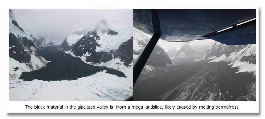
The slide started at about 10,500 feet, fell over a mile and ran out five and a half miles on the Hopkins Glacier. The image on the left shows the slide debris on top of the Hopkins glacier. The image on the right is from the photographers airplane (Drake Olson). The slide travelled a mile and a half down the steep mountainside then ran out along the Hopkins Glacier another four miles before coming to a halt. Debris from the slide was scattered 200 feet above the level of the slide deposition zone and included gravel up to 15 inches in diameter, dust up to 1500 feet above the slide zone and fist sized rocks “peppered” in a wide area even higher than this. The flow had such a high velocity that it super elevated the outside of the curves up to 100 feet above the inside.
In the image on the right, on the right hand side of the valley, several (or more) snow slides were triggered by the landslide. Evidence of these snow slides is obvious from the fresh slide fields of snow and ice deposited on top of the landslide debris zone.
We know that the slide originated in a permafrost zone, and we know that high altitude slides are increasing around the world. We know that permafrost melt can be responsible for slides like this. We also know that heavy snowpacks melting rapidly can cause slides like this. And indeed, this year the Glacier Bay area saw heavy snowfall and a rapid melt.
Reference:
Proceedings of the Cold Regions Landslide Network, Harbin, China: Initial observations of the 11 June 2012 rock/ice avalanche, Lituya
Mountain, Alaska.
http://www.nps.gov/glba/parknews/upload/2012-Landslide-Report.pdf

