
Beach Report: King Tide October 2017
October 20, 2017
The King Tide was on. King tides, spring tides, perigean spring tides (all different names for the same thing) happen in October and April when the sun and moon both align to raise the normal high tide by several feet sometimes. The extra high tides come in groups, with several days a week having extra high tides, alternating with more normal high tides and this sequence last for the better part of a month.
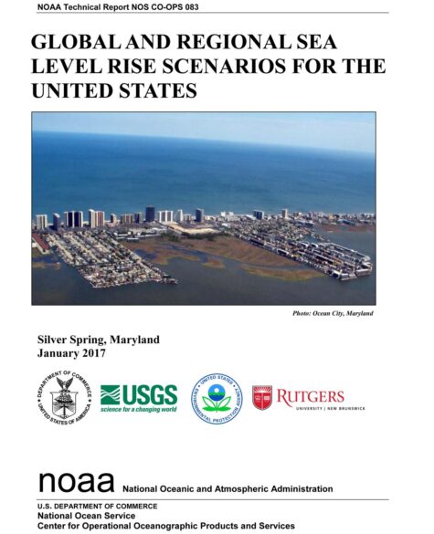
At their highest now, the King Tides cover the entire beach and erode into the dunes. This never happened before 2013 on the Texas Coast.
Padre Island National Seashore (PINS or the National Seashore)
The wild beach was closed three times this year from high tides, once from Hurricane Harvey, twice from the King tides in the spring, all before the biggest King Tide, likely ever. Then in October, November and December, the beach was closed over a dozen times because the tide was into the dunes. Virtually the entire 60 mile wilderness beach has one to 8 feet of recent vertical dune erosion with about 70 percent averaging 4 feet. Only the northern 10 to 15 miles of the National Seashore experienced erosion from Harvey.
In 2008, Hurricane Ike built about 50 to 100 feet of beach from significant dune erosion. Since then, new dunes began building about 60 to 100 feet out from the old eroded dune line. Down the beach (north to south) to Yarborough Pass at Mile 18, it is largely these dunes that are now eroding. From Yarborough to about Mile 50, erosion is two to four feet and extends into the original dune field. From Mile 50 to 60 at the end of the National Seashore at Mansfield Pass however, only one row of dunes remains. Usually there are several rows extending back into the inner reaches of the island. In the worst areas now, erosion has all but taken the dunes.
More evidence of the recent erosion remains in places where black organic rich sand has been exposed. The roots of dune stabilizing plants in these areas extend upwards into the air several inches like a buzz haircut. Any extra debris from Harvey was not evident. Driving was excellent to poor depending on the tide level. After about mile 20, many places were very wet during high tide and impassable without extra large tires and lifted vehicles. The flats were completely inundated behind the island. The shorebird migration had begun, but only about twice the usual number of birds were passing through.
How Bad Is It?
NOAA’s new sea level rise report in January 2017 calls for the worst-case scenario of 10.5 of sea level rise by 2100. The worst-case scenario? Could it be this bad? We should be asking if it could be worse.
Sweet et al., Global and Regional Sea Level Rise Scenarios for the United States, NOAA, January 2017
Past projections of impacts have been grossly underestimated. Forest die-offs, the Amazon flip, drought, flooding, the failing of the Gulf Stream, and now sea level rise from ice sheet collapse.
One of the best examples of the worst-case scenario being much less than has actually already occurred is ice loss from Antarctica. As recently as the 2007 IPCC report, Antarctica was not supposed to begin losing ice until after 2100. In the 2013 IPCC report, Antarctic ice loss has begun, and has increased to at least half that of Greenland. It was not that Antarctica suddenly began losing ice, first publishing on the topic began was in 1996. The challenge is that the IPCC, and in fact almost all science, is conservative. It understates because scientists cannot afford to be wrong or their credibility is questioned.
So science in general understates and a consensus such as the IPCC understates even further, because to gain consensus with so many scientists, compromises must be made. There are many reasons climate science understates, but sea level rise has its own: we cannot yet robustly model ice sheet collapse.
We have excellent models that can recreate ice cube melt modeling, but collapse is another thing altogether. We know that collapses have occurred in the past and we have exhaustive evaluation of prehistoric evidence of abrupt sea level jumps of 10 to 20 feet per century here. The bottom line is that ice sheet collapse is more like an avalanche than a melting ice cube. To get 20 feet of sea level rise per century, ice sheets literally have to disintegrate and flow into the sea like a bag of crushed ice poured into an ice chest.
The reason we do not have sea level rise projections of anything greater than a couple of feet per century is because these crushed ice collapse events are just not yet robustly modelable. But some scientists are saying the obvious. Margaret Davidson (now deceased), NOAA’s chief sea level rise scientists in 2016, said that data know collected by yet to be evaluated and published, shows evidence that we could have 10 feet of sea level rise by mid-century. (see link above)
NOAA’s New Report: What it Means
NOAA, in a major report in January 2017, says that we can expect 9 inches of sea level rise by 2030. (review of the report)
The significance of this relatively small sea level rise is two fold: 1) it is just the beginning. AS ice sheet collapse moves forward, sea level rise increases nonlinearly, and 2) Nine inches of sea level rise will increase nuisance flooding by 25 times. The reason is that most beaches have an immediate elevation of two or three feet and this is about the same the normal tide range. Take away part of this elevation gain and suddenly high tide rises above this “beach ramp” and moves into the flats behind the beach where all the development is and nuisance flooding has the ability to move far inland.
The Union of Concerned Scientists tells us that when we reach this threshold of nuisance flooding increasing 25 times we will be in the resource abandonment stage. What this means is that flooding will become so frequent that property owners will no longer be able to afford rebuilding, insurance will be gone and folks will just walk away. This will all be underway in just 12 years.
Port Aransas and Harvey
Power is still out in what seems like more places than were the power is back on. Coming into town from Corpus along Mustang Island a new and completely out of place mountainous object appeared on the horizon, it looked like a 60 foot tall sand dune but there are no sand dunes in that area of Port A. Close up, it was a flood debris transfer station. Trucks lined in and out. A massive trackhoe with a gaping jaw large enough to fit a Volkswagon Beetle had clawed its half way up the pile to better manipulate the debris.
Traffic was very light. Hurricane debris were over head-high in windrows that lined every street, both sides. The stoplight at the main intersection adjacent Trout Street Station was gone and replaced with a single stop sign in the middle of the road embedded in an old tire full of concrete. Traffic was so light that even this was unnecessary.
A couple of the largest, two-story tourist souvenir and T-shirt shops had their floor to ceiling windows completely blown out and had been gutted by the owners for repairs. Only the new condos on the south side of town had no visible damage. It seemed like every building in town was damaged, some catastrophically.
Two of my favorites, the Laughing Horse Inn and Rock Cottages, both had extensive roof damage and were blue-tarped. An old friend told me the Laughing Horse would have to be torn down. The damage was just too extensive.
The beach had zero erosion damage, which was very odd but considering the path of storm, explainable. Harvey gained strength so fast its surge had only built up on the windward side to the east and north. Because the eye moved inland to the east, Port Aransas to the south experienced an offshore wind as the hurricane’s tempest circulated counterclockwise around the eye. The flood came from the bay and was evident in the large piles of sea grass and other organic debris that remained south of town along the back side of Mustang Island.
A lot of open water now occupies Port A. For most, this is nothing new as many of the ditches in town and many old lots in the southern half of town have been perennially wetlands in their memory. But 30 years ago, only a few ditches had cattails and no lots in the south part of town were perennially wet. Sea level rise of only 3 to 4 inches has raised the water table to where it now intersects with many of the ditches in town. Those lots that were not developed that lie at the lowest elevations, had now turned to open water.
I took no pictures, made no video. In 1979, my family home was flooded during Hurricane Claudette. I apologize for not having images. The reporter in me was overcome and I could not stop to photograph. All I have to report from Port A. is my words.
By the time I got to the Ferry (one of my favorite parts of going to Port Aransas), I was just about as depressed as a kid could get. The line of cars for the ferry filled the big hairpin queue that extends a quarter mile behind the sailboat basin and spilled out back into town about a block. It wasn’t moving. I was trapped for ten minutes and no ferries came across, no boats blocked the way. The wait is no problem if there is someone to wait with.
Rockport, on the other side of the ferry, was hit as bad as Port Aransas I hear tell. I bailed out of the line and drove back to Corpus Christi south along Mustang Island the way I had come, to make my way back to Austin.
South Padre Island 10/20 to 10/22/2017
My wife gets to ride shotgun a bit these days now that our kiddo has grown. She likes to come to the beach with me when I film so she bird.
This trip, water was reported in the streets of South Padre Island at the Ocean Motion souvenir shop three weeks ago. The water came up from the storm drains and flooded onto Padre Boulevard in front of the store. This is the first non-storm occurrence of this kind of flooding that I have heard of on the Texas Coast.
We arrived at about 5 Friday and picked up a room at La Qunita Inn beachside, then jumped back in the truck and headed up the beach to the end of pavement and Beach Access #6. Up the island so far, far beyond the condos and towers, blowing sand constantly tries to cover up the road. Ten-foot tall dunes move relentlessly over the pavement only to be beaten back by the County front end loaders. This time, water covered the edge of the road for no reason. No bar ditch, just a ten foot tall line of dunes partially over the pavement, with a puddle two or three inches deep extending down the road for hundreds of feet at a time.
The surf had come through the Beach Road #6 access and spilled out onto Padre Island Drive. The tide was that high.
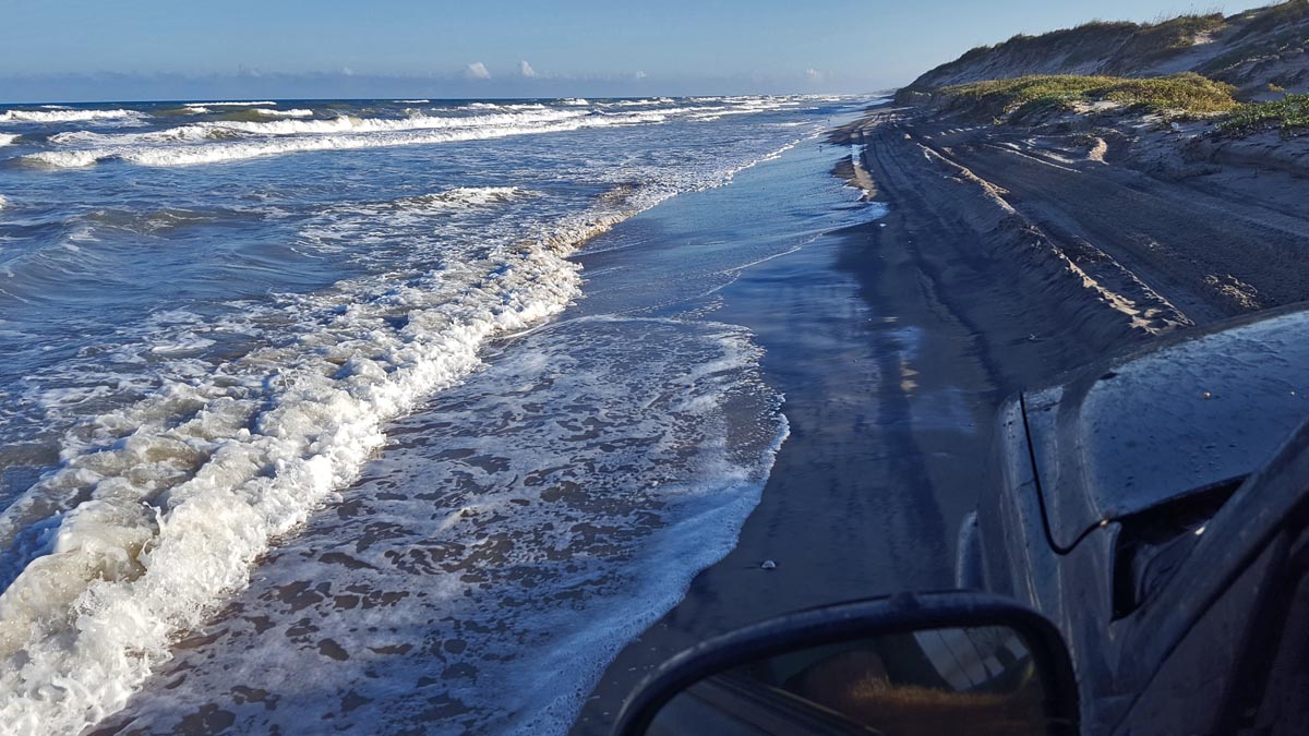
Just getting to the beach this time was a challenge. The sand was so soft on the access road that it was obvious that numerous vehicles had been stuck; not while we were there fortunately. And for us, a push button and we were in 4×4 with our big tires and custom lift. Not a problem.
This day, high tide was about 5:30 and there was only room for beachgoers to park their cars right next to the dunes, leaving up/down beach traffic one lane between their cars and the edge of the surf.
Just a quarter or a half mile up the beach and the tourist packed sand had disappeared along with the two-wheel drive vehicles. It was deep sand and 4×4 only. The beach was about 20 feet wide from the edge of the dunes to the edge of water with a few town cars that had been there since the tide was lower, having driven on the hard packed sand.
South Padre Island, King Tide, October 2017
It’s such a hard thing to describe. I feel like I am failing. The beach was gone. It was covered up with water. There was no storm. Blue skies stretched from horizon to horizon. But the beach was gone.
Beachgoers in four-wheel drives struggled to share the tiny trail. When somebody stopped to party, enjoy or fish, we had to slow to the slowest of crawls as we passed. The kids running around; families just are not accustomed to the beach traffic being so close between them and the surf. Sometimes there was simply no room and we just drove out into the shorebreak to get around. We could literally, almost lean out the window and touch the back of their truck or SUV.
This beach is such a beautiful beach. Even covered up with water like it was. It’s not like the National Seashore to the north. It’s drier on South Padre Island and the sea grass grows slower. This means open sand is much more widespread than on PINS. It drifts into giant dunes fifty feet high that extend in fields of blowing sand for a half mile or more across the island.
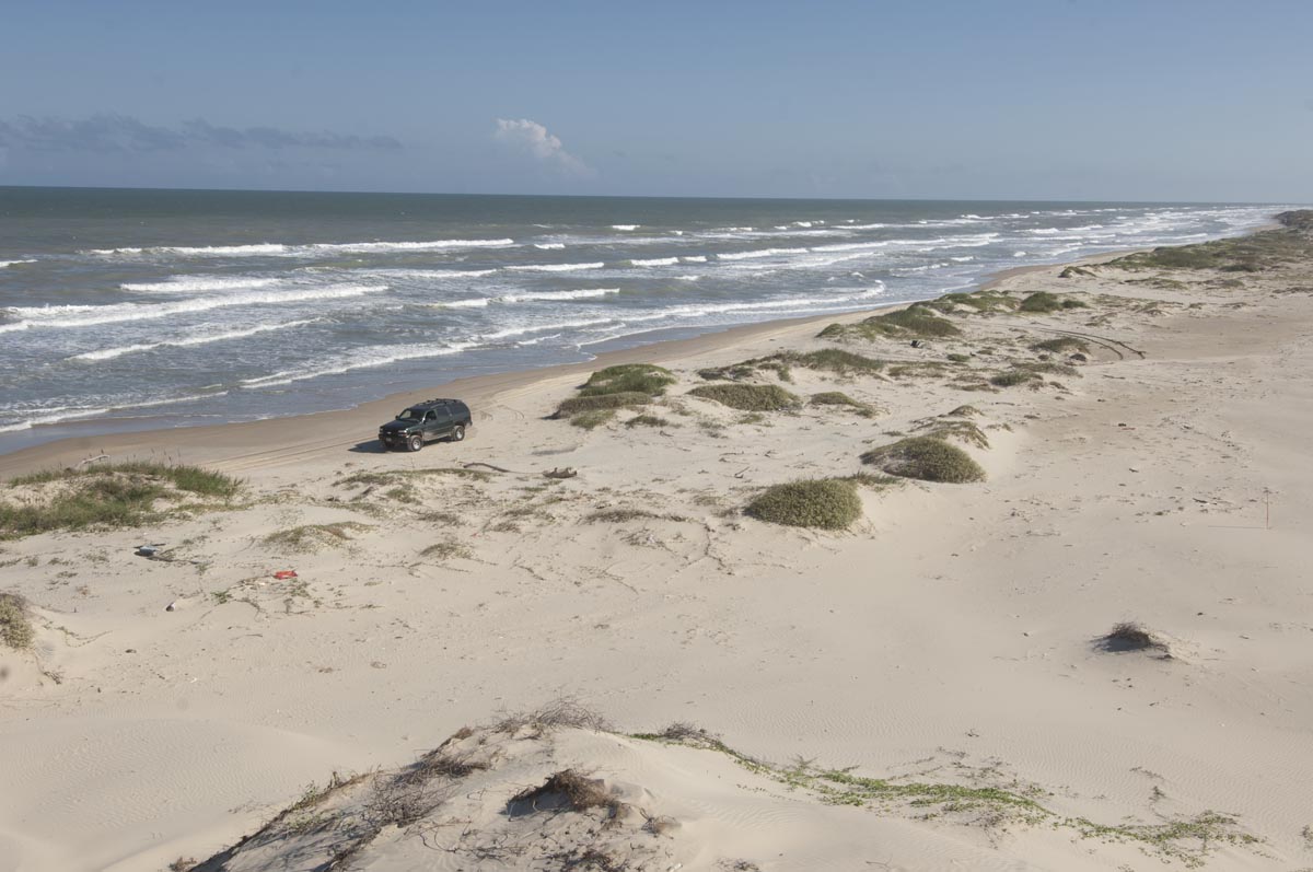 At a place called The Narrows, where historically the beach is narrow for some geologic reason, almost all of the dunes have been eroded away. All that remains is the low sand hills of the salt grass flats that were formerly “behind” the main formation of dunes. Now the surf breaks right up to the edge of the flats.
The sand was so deep and soft that the tire cleats threw it up onto my running boards several inches deep. When I got out once to suction cup an action cam to the hood, the pile extend along nearly the entire running board three inches deep.
South Padre Island, about mile 10 beyond end of pavement. Foredunes eroded almost completely away.
The tide was cresting and with every set of breakers half of the waves rolled all the way to the dunes. It was slow going to keep the salt spray from splashing too bad. That salt water is murder on vehicles these day. Little sandbergs slid down the eroded dune faces as we passed.
We were driving along a trail that was inundated half the time. It was only about 20 feet wide when the waves washed out. When the water was out, we sped up. When waves rolled in, we slowed to a crawl and let them wash up under the truck.
We made it up the beach to about mile seven before we decided we should turn around and drive out in the daylight.
At one particularly challenging place a bigger than usual wave rolled up under the truck that I fortunately slowed in time to meet. I got out at the next high spot to pull the action cam off the hood and all the sand was washed off the running board. The water was that high. ( I later leaned that my transmission had injested sandy salt water through it’s breather. It killed the transmission by Christmas. The new tranny has a modded breather tube up in the engine compartment…)
I’ve never driven the beach with the tide so high. There was just no beach left and the dunes were eroding badly. It was like the Gulf had just sliced the dunes right off. Where the breakers hit the dunes the sand went nearly vertical; sometimes as high as 15 feet.
We made it back to pavement in time to get some shrimp at Blackbeard’s, then I hit the powerwash and ran about five bucks through, down on my hands and knees blasting away at the underside of the suburban to get the salt off. I had to replace a rusted out drive shaft last year, and I wash the truck–a lot–every time I get off the beach. After the wash we took our usual town drive through South Padre and back across the causeway, just because.
Back at the hotel, we checked out our room view, priceless. But we were on South Padre, no time to sit in our room–even late, after a very long day of driving and then beach 4×4. So, downstairs to the beach. The tide was down a bit, it was 20 or 30 feet from the bottom of the stairs to the edge of water. We hung around talking to folks, watching the kids chase ghost crabs with their flashlights. The beach here at the condo and hotel towers was pedestrians only and a gang of folks had accumulated at the end of the stairs just hanging, enjoying the late evening, the stars and the breaking surf.
A big wave pushed us all right up next to the little dunes out in front of the hotel. We had been standing around for about twenty minutes and we must have started to look like locals or something. A couple approached us and asked “Are you from here? Can you tell us what this is all about?”
It was obvious. They were looking for the beach. I told them that no I wasn’t from here, really, but I was a filmmaker and climate change guy working this weekend and yes I could tell them. Turns out, they had grown up in Brownsville, had always spent a lot of time at the beach here, and had moved to Houston and had not been back in 15 years.
He said what they usually do: “The last time I was here, when I grew up here, it used to be that, it was hundreds of feet to the water. Where’s all the sand? Where did the beach go?”
“It’s not like this always” I tell them. Then I explain about the King and Spring Tides. And “yes, it’s definitely sea level rise from climate change. There’s little to no man-caused subsidence around here.”
South Padre 10/21/2017
Hotels with a huge breakfast buffets included are so nice… We ate at the big meeting room on the seventh floor at about 8. Of course we ate way too much.
The tide was low, it was a two-tide day. This is how the King and Spring tides work: half the time it’s a two-tide day: one high tide and one low tide. The other half there are four tides, two highs and two lows and the water doesn’t go in and out very much. It’s the two tide days that have the biggest tides.
We had the full day and the tide was low and driving good on the packed sand. The beach was still pretty deserted and the shorebird migration had not yet materialized this far south. But the beach art was here.

South Padre Island mile marker 6 beach art.
A local picks up beach debris and repurposes it into art way up the wilderness beach where few tourists can be found. There’s a hundred hard hats on a hard hat tree. Or a minora of discarded Bic lighters with a trunk of multicolored flip flops. There was a dragon last year, made of all sorts of stuff, and a beach man or woman, with swim goggles for a face and black flex tube for arms and legs.
The tide started coming up right after lunch and was pretty high by the time we made it all the way to Mansfield Pass, 23 miles beyond the end of pavement. Mansfield Pass is what divides the 60 mile long Padre Island National Seashore to the north from South Padre Island. The pass is a typical deep water pass with granite jetties on both sides. It was a part of a land development scheme in the sixties that the Corp of Engineers got talked in to supporting. There’s still almost nothing over on the mainland at Port Mansfield except the massive King Ranch and about a thousand wind turbines that weren’t there six or seven years ago.
It’s cool destination at the end of a long wilderness beach drive. Swells from the Gulf ride between the jetties and crash on the rocks. Fisherman sit here and there, or balance on jetty rocks tossing lures. The sky is blue and civilization is hours away.
The return trip was a little more interesting. By the time we started rolling back towards the towers the tide was really surging in. By the time we were half way back, the big swells were running up all the way to the foot of the dunes, under the truck. Every time I experience this, it’s was hard to imagine it is real.
The challenges were the same as yesterday: slow down to a crawl when a wave washes up, speed up when it washes out. Still, every fifteenth wave or so you mistime and tire spray flies up the air above the top of the truck. More than once a small dune calving would avalanche down as we motored by.
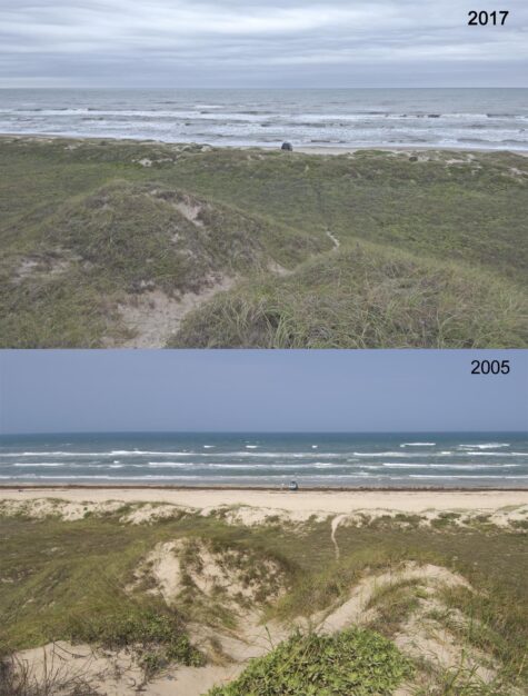
When I completed our film “The Ice and The Sea” in 2009, none of this erosion had begun. The beach started getting smaller back in the late 20th century, but the dunes were not being regularly eroded like today. Before 2000, and especially back in the early 1990s, the beach was a hundred yards or more from the high tide line to the edge of the dunes. By 2007, three quarters of the beach was gone. In 2013, at least on Padre, the King and Spring Tides regularly began to erode the foot of the dunes.
Padre Island National Seashore, mile 25 south from end of pavement at Corpus Christi. This is “The Big Dune.” It stands alone way down the 4×4 only beach and has been the object of my repeat photography for more than a decade.
We stopped for lunch at a prominent point where one of the biggest dunes showed one of the biggest erosion faces. It must have been 12 to 15 feet. Interestingly, the beach was really wide here. Erosion from such large dunes had washed a much larger amount of sand down into the shorebreak zone. The eroded sand had washed out into the surf and created a long flat expanse of sand.
I stopped just above where the breakers were washing; made made us a couple of sadwiches, and took some, photos. Jeannie birded. By the time I finished, water from the rising tide was an inch deep on the tires and we proceeded on down the beach eating our sandwiches on the way.
The sand was soft. No two-wheel drive touristas here.
We made it back to to beach access #6 at the end of pavement about sunset. Beach goers were still drawing out their last bit of beach time, crowded near the access, their cars backed up to the dunes, with no room remaining for other beach goers to drive by. So they drove by anyway; in the surf. The sand in the surf is hard packed, but just up out of the water, not so much.
Not ready for our odyssey to end, there was another stretch of beach between Access #6 and Access #5 that we had not yet driven. We decided to go on to Access 5. Four or five hundred yards down the beach beyond Access #6 the tourists disappeared and we were alone with the tide once again for another three miles.
The glory light was fading in the west and out over the Gulf, a deep indigo band showed just above the horizon where the terminator, the atmospheric transition from day to night, was just rising to end the day. The last bit of color in the sky was reflected off the Gulf in a combination of fuscias, magentas and yellowy sea green. A wave washed up beneath the truck as we skirted an eroded dune face. We stopped and stared in wonder, then rolled on when the wave rolled out.
The tourist density began to increase as we neared what we thought was Access #5. Virtually zero beach remained between these people’s autos, many of them tiny little two-wheel drives. The surf run-up from shorebreak beat under their cars. To get past these fun-lovers, one had to drive in the water, or at least in the water whenever a wave rolled up the beach. Up- and down-beach traffic had to wait to get around, or risk driving out into water that was too deep.
The number of cars and beach goers increased rapidly the closer we came to the access. Up ahead a steady line of vehicles–driving in the water that was continuing to rise, was headed towards the escape.
On the dune side of the line of parked cars that remained with their beach goers now limited to a tiny sliver of little wider than their cars were long, a sheriff in a 4×4 Tahoe was literally plowing sideways through the deep sand, perilously sliding this way and that towards the rear of the beach goer parking lot. The line of vehicles in the surf had stopped. I pulled up onto the foot of the dunes to get our of the way and watch the fun.
The line of cars in the surf remained stopped, surging shorebreak thumping up against the undercarriage of the low-slung two-wheel drives sedans. The sheriff continued to careen here and there in the deep sand, slowing nearly to a stuck stop again and again. Beach goers stood around with puzzled looks on their faces. The faces of drivers in tiny cars were pale and drawn.
The sheriff made it around the stopped line of cars in the surf and passed us sitting in our machine. I raised two fingers from my steering wheel. He raised one finger from his steering wheel with a serious look on his face.
A circus by any other name. Getting out through Access #6 seemed to be a long-term proposition. We turned about to head back to #6. It took a three point turn to keep from driving out too deep.
As quickly as we had motored down into this melee, we drove out of it into the relatively tourist free zone of four-wheel drive society. The blue violet band of darkness was raising into the sky as the afterglow in the east faded further. The Gulf was now steely. A few laughing gulls cruised along with us, laughing as they looked back over their wings at the circus.
We were alone again as the tide rose higher and higher. Slow down, speed up, slow down. Feel the fresh breeze after the heat of the day at the same latitude as Miami Beach. Enjoy the rhythmic surf sounds through open windows.
At Access #6, most of the beach goers had departed. Commotion appeared way up ahead in the form of rapidly and oddly moving vehicles. We trundled on. Sometimes at 10 mph, sometimes almost stopped. A lifted truck with a suntanned arm on the window sill had stopped to let us by. We stopped abreast, water running up under the truck. He spoke first.
“Yeah, nice evening.”
“Incredible,” I said.
“Come here often?” I said. He replied “Not like this!”
“Can I get out up there?” I queried.
“Maybe by now.” he said “It’s a mess.”
“We’ll take our time.” I responded.
He replied “Good idea.”
At Access #6, the carnage could be read in the ruts, near a foot deep in the deepest softest sand, for a hundred yards up to pavement, a hundred feet wide, it looked like one could have lost a Prius in there. Two lifted trucks were parked along the edges of this sand channel. Their pilots were standing near, arms folded, waiting. One of the trucks had a heavy tugboat hawser looped around an oversized brush hog bumper guard; obviously used to pull hapless tourists out of the sand.
I shuffled the truck to the left a bit, the bow of the suburban slicing through the deepest hole. I stopped adjacent the two standers-by, at the worst place possible as if in defiance of the sand gods, knowing my wide footprint would not fail us. The wife never blinked.
“How many stuck at once?” I asked out the perennially open window. “Four!” one of the pullers shouted and they both laughed. “Very Cool.” I replied, then dropped my arm from the windowsill and gave them a low wave as I slowly rolled off, never spinning a tire.
Rockport: Six inches of sea level rise in the last 10 years, one foot since 1990. Rockport’s average is 5.52 mm/year. Rockport has higher than average subsidence.
https://tidesandcurrents.noaa.gov/sltrends/sltrends_station.shtml?stnid=8774770
SLR average on the Texas Coast is 4 to 5mm per year.
http://www.texasasbpa.org/site/wp-content/uploads/2017/05/TexasASBPA_Symposium_Presentation_Tissot_Reisinger_Besonen_rslr.pdf
Hauer, Migration induced by sea-level rise could reshape the US population landscape Nature Climate Change, April 17, 2017.
Paper — https://osf.io/preprints/socarxiv/hfr96/download
Presentation — https://www.ipops.fr/fichier/rte/9/MUTADEMO%2022%20-%2023%20SEPTEMBRE%202016/PRESENTATIONS/Session%206/Presentation_hauer.pdf